
Новые материалы из архива А.И. Шренка: к истории создания Каркаралинского укрепления
Научная статья
Просмотры: 267 / Загрузок PDF: 162 / Загрузок PDF: 59DOI:
https://doi.org/10.32523/3080-129X-2025-152-3S1-32-47Ключевые слова:
А.И. Шренк, архив, брульен, военные топографы, Каркаралинск, окружной приказ, письменные источники, путешественникАннотация
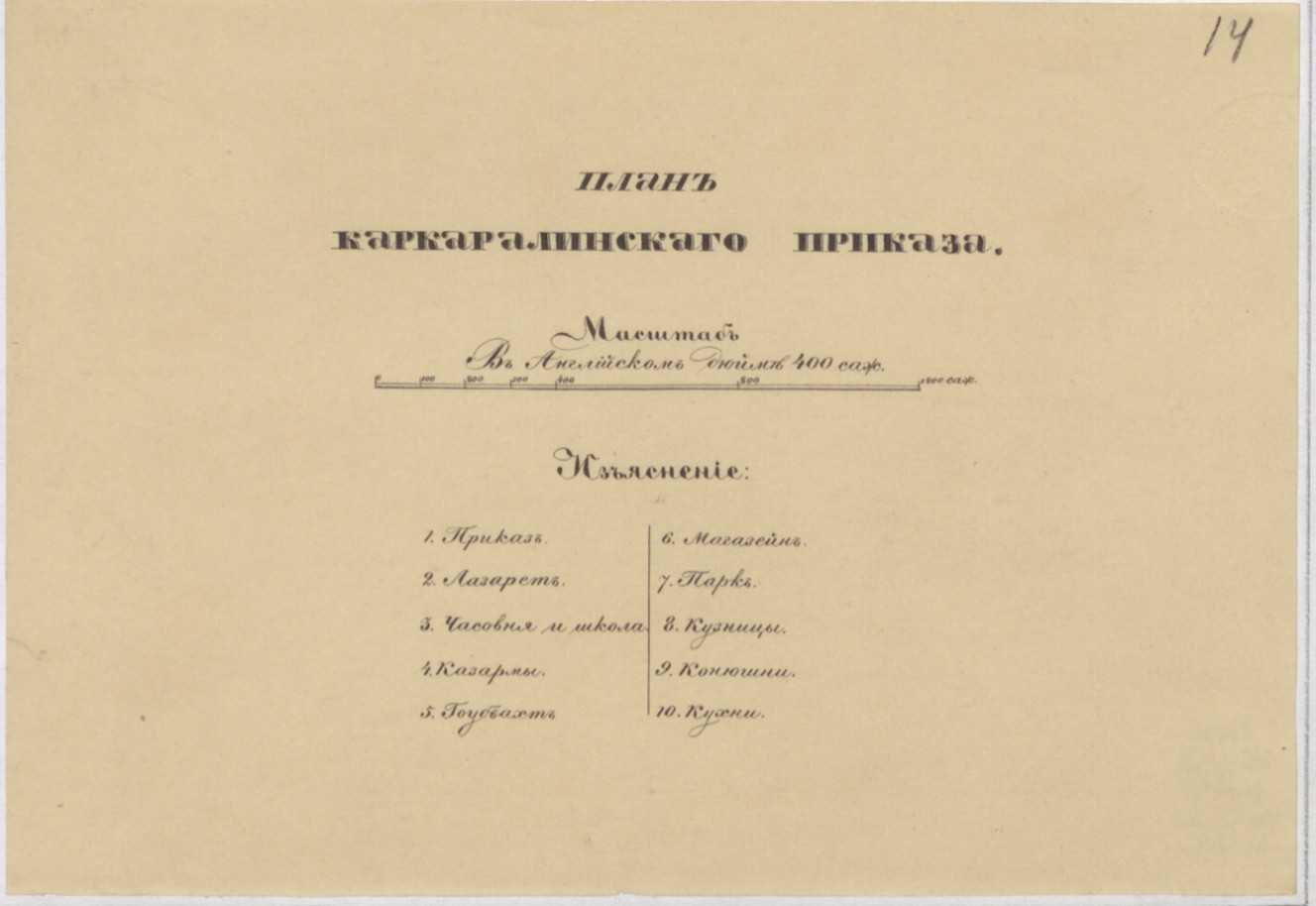
В 1824 году был основан Каркаралинск как место расположения одного из первых окружных приказов Российской империи, созданного для управления внешними округами на территории казахских степей, что стало прямым следствием административной реформы 1822 года. В статье анализируются письменные источники, на основе которых ученые описывали развитие Каркаралинска как административного центра и военного укрепления внешнего округа Омской области в конце 1830-х – начале 1860-х годов. Письменные источники дают лишь приблизительное представление о планировке и застройке города. Впервые проводится источниковедческий анализ плана Каркаралинска, который хранится в Санкт–Петербургском филиале архива Российской академии наук в документах фонда № 317, содержащего заметки учёного, ботаника Российского императорского ботанического сада, приват–доцента геологии и минералогии Дерптского университета, путешественника А.И. Шренка (1816–1876). В 1840–1843 годах он путешествовал по «Киргизским и Зюнгорским» степям и несколько раз посещал Каркаралинск и его окрестности, собирая гербарий, записывая интересные этнографические и исторические сведения, отмечая памятники старины, в том числе древние курганы. Используя информационный потенциал картографических материалов, некоторые из которых до сих пор недоступны широкому кругу исследователей, таких, как карты и планы из архива А.И. Шренка, автор представляет научному сообществу первое картографическое изображение Каркаралинска. Впервые было проведено источниковедческое исследование этого плана, где использована система символов и знаков, иллюстрирующих процесс строительства Каркаралинского укрепления. Использованы специальные обозначения и цифры, показывающие расположение важных правительственных зданий и военной, экономической и социальной инфраструктуры. При составлении модели изучаемой территории в исследовании применяются как картографический, так и сравнительно-исторический методы, анализируются письменные источники для выявления различий и хронологических несоответствий в свойствах объектов. В статье раскрывается информационная ценность источника, обоснована датировка и выдвигается гипотеза о разработке брульена военным топографом А.М. Яновским. Сравнение изображения с данными письменных источников выявляет существенную, хотя и неполную связь, которая открывает возможности для дополнительного изучения выявленных объектов.
Скачивания
Библиографические ссылки
Bezvikonnaya E. Administrative-territorial structure of the Kazakh steppe in the first quarter of the 19th century (opening of external districts). Bulletin of Omsk University. 2001. No.3, pp.57–60.
Berlyant A. Cartographic research method. Moscow: Moscow State University Publishing House. 1988. 252 p.
Eyries J.-B. Picturesque journey through Asia. Moscow: N. Stepanov Printing House. 1839. Vol.1. 600 p.
History of Karkaraly in Documents and Materials. Eds. K.S. Aldazhumanov, A.Z. Beisenov. Almaty: no record. 2008. Vol.1. 494 p. 2009. Vol.2. 508 p.
Historical essay on the activities of the Corps of Military Topographers 1822–1872. St. Petersburg. 1872. 787 p.
Kraevsky A. Bulletin of the Imperial Russian Geographical Society. St. Petersburg: Publishing House of E. Weimar. 1851. Part 1. Book 1. 666 p.
Krasovsky M. The Region of the Siberian Kirghiz. Materials for the Geography and Statistics of Russia. St. Petersburg: bibliographical collection. 1868. Vol.1. 427 p.
Ksenzhik G. Cartographic Materials on the History of Kazakhstan in the 18th – Early 20th Centuries: in the Context of the Formation of State Borders. Almaty: N-PRESS Publ. 2020. 376 p.
Lipsky V. Flora of Central Asia. Part 1. Literature on the Flora of Central Asia. St. Petersburg: Tipo-Lithography “Gerolda”. 1902. 245 p.
Makisheva A. History of the Formation of the Bayan-Aul Okrug of the Middle Zhuz. Bulletin of the Peoples Friendship University of Russia. History of Russia Series. 2013. Is.4, pp.40–45.
Margulan A., Orazbaev A., Kadyrbaev M., Akishev K. The Ancient Culture of Central Kazakhstan. Alma-Ata: Nauka Publ. 1966. 434 p.
Popov Yu., Ryazantsev V. The Kornilovs, Karbyshevs, Ryazantsevs, and Other Cossacks of the Karkaralinskaya Village (Historical Chronicle Details). Novosibirsk: ARTA Publ. 2012. 142 p.
Smagin R. Military Topographic Service in Siberia in the 19th–Early 20th Centuries: Dissertation… by a Candidate of Historical Sciences. Novosibirsk. 2015. 366 p.
Schrenk A. Bericht über eine, im Jahre 1840, in die östliche Dsungarische Kirgisensteppe unternommene Reis: Aus dem Russischen Manuscripte übersetzt von C.A. Meyer. St. Petersburg: During the Imperial Academy of Sciences. 1842. 69 p.
Schrenk A. Journey of Doctor of Philosophy A. Schrenk in 1842 to the Eastern Dzungarian Kirghiz Steppe. History of Kazakhstan in Western Sources of the 12thV.–20th Centuries. T. V. German Researchers in Kazakhstan. Part 1. Edited by I. Erofeev. Almaty: Sanat. Publ. 2006. Рp.137–174.
Загрузки
Опубликован
Выпуск
Раздел
Лицензия
Copyright (c) 2025 М. Бедельбаева

Это произведение доступно по лицензии Creative Commons «Attribution-NonCommercial-NoDerivatives» («Атрибуция — Некоммерческое использование — Без производных произведений») 4.0 Всемирная.
Как цитировать